The satellite images captured by Maxar Technologies showed a nearly 3-metre-wide crater just 30 metres from the entrance of a heavily fortified sub-complex within the Murid Air Base—an area protected by double fencing, watchtowers, and tight security protocols.
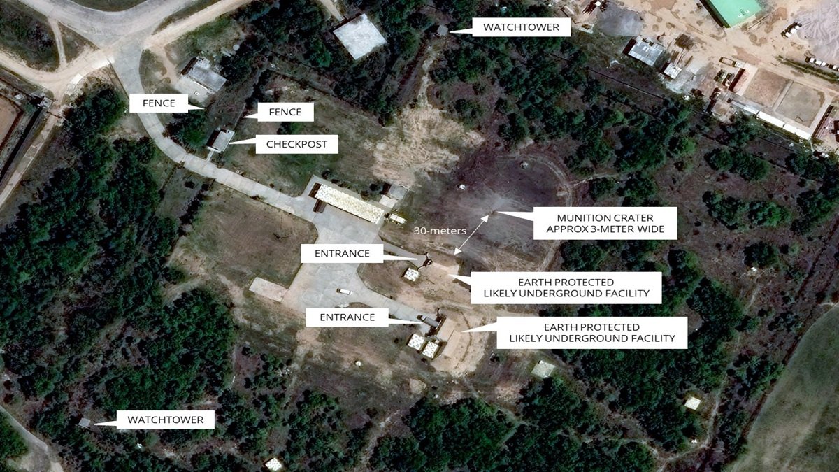
The airstrikes during Operation Sindoor on Pakistan’s Murid Air Base might have targeted a suspected underground facility, newly released high-resolution satellite images showed. High-resolution satellite images on Wednesday revealed extensive damage to the Murid air base in Pakistan, showing a three-metre-wide crater just 30 metres from an underground facility of the Pakistan Air Force and damage to the rooftop of a structure adjacent to unmanned aerial vehicle hangars.
The satellite images captured by Maxar Technologies showed a nearly 3-metre-wide crater just 30 metres from the entrance of a heavily fortified sub-complex within the Murid Air Base—an area protected by double fencing, watchtowers, and tight security protocols.
As per the updates from Damien Symon, geo-intelligence researcher at the Intel Lab, the crater’s proximity to what is believed to be an underground structure has raised speculation that India aimed to strike deep-buried assets, possibly linked to command-and-control functions or drone operations.
Moreover, the airstrike appears to have broken the perimeter defences of this high-value zone, indicating the use of precision-guided munitions and deep-penetration targeting. If confirmed, this strike could be the first known instance of India attempting to disable subterranean military infrastructure in Pakistan.
The damage in other places of the airbase is visible to the roof of what appears to be a command-and-control building adjacent to a UAV complex and hangar. The roof of the airbase shows clear signs of impact, with indications of internal damage, suggesting a direct strike, said Symon.
In the meantime, the Maxar images of Nur Khan air base, which was affected during Operation Sindoor, showed a broader than initially estimated damage footprint.
The latest satellite images captured after the strikes showed that a building complex near what was initially assessed to be India’s primary target was “demolished”, said Symon.
While primary observations on May 10 indicated the destruction of special-use trucks, the latest images indicate structural devastation that may have rendered parts of the base inoperable and beyond repair.